Friday, January 6, 2012

Mountains: The Cascades


Mountains: The Cascades
The Cascade Mountain range stretches across much of the West Coast, providing beautiful scenery and many recreation opportunities.

For Earth scientists, the Cascade Mountains are one of the most important features in our state. Why?
The Cascades are so important because they are a significant example of the role of plate tectonics in shaping California millions of years ago.

Also known as the Cascadia subduction zone, these mountains were formed by the constant movement of tectonic plates in the lithosphere.
An ancient tectonic plate called the Farallon plate formed a convergent boundary with the North American plate, starting in Northern California.

Because the Farallon plate was a denser oceanic plate, when it came together with the continental North American plate, the Farallon gradually sank.
As the Farallon plate sank, it partially melted because of contact with the heat of the mantle. Magma (very hot rock) from this melting began to rise to the upper layers of the Earth.

Through this process, many volcanoes formed in the Cascade Range, including Mount Shasta, Lassen Peak, and Mount St. Helen’s.
This convergent boundary was so active that the Farallon plate eventually sank completely under the North American plate. Therefore, the Farallon plate does not exist today!
Tuesday, January 3, 2012

Earthquakes: The 1989 Loma Prieta Earthquake


Earthquakes: The 1989 Loma Prieta Earthquake
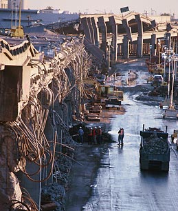
Even though it wasn’t an extremely large earthquake, the Loma Prieta earthquake made a big impact in the Bay Area.

Because the 1906 San Francisco earthquake had been so terrible, places built here after it had to be made earthquake-safe.
But some of these “safe” buildings collapsed or were damaged in the 1989 earthquake, showing people in the Bay Area that more had to be done to prepare for an emergency.

And the damage did not just happened in poor areas, or in areas where not very many people lived. Cities and communities across the Bay Area were affected.
In fact, the Bay Bridge – the biggest transportation hub in the Bay Area – was damaged. Local leaders took the threat of an earthquake so seriously that they just finished making it more earthquake-safe last year (more than 20 years later).

These effects made Bay Area residents re-consider what is truly earthquake-safe. It also made them consider emergency preparedness as a priority again.
And in this way, the Loma Prieta Earthquake affected the Bay Area positively, despite all the physical damage.

Sunday, January 1, 2012

Earthquakes: The 1994 Northridge Earthquake


Earthquakes: The 1994 Northridge Earthquake
The Northridge earthquake is significant because it is the most recent earthquake to occur in the San Fernando Valley. And more importantly, it was the costliest (most expensive) earthquake ever in the United States.
Even though this city environment was built to stay standing even in the worst earthquake, the 1994 quake showed that there was still a lot of room for improvement.
Some buildings collapsed or damaged, and some even caught on fire. This showed people living in the San Fernando Valley that even the earthquake-safe buildings were not safe enough.
As the city recovered and rebuilt freeways, parking structures, and buildings, they decided to make buildings even safer. They did this using new technology and stronger materials.
The city got safer in other ways too. Now, schools and public organizations are required to do earthquake drills so that people will know what to do in an emergency.
And police, fire fighters, and emergency medical workers are trained in emergency preparedness (being prepared for an emergency).
All of this has helped make Los Angeles a safer place should another earthquake occur here!

Wednesday, December 28, 2011

Earthquakes: The 1906 San Francisco Earthquake


The 1906 San Francisco Earthquake
Many scientists consider the “Great Quake” of 1906 as one of the most important in history. But why?
It is not the largest earthquake ever or the most destructive one. The San Francisco earthquake, however, had long-lasting effects other than the collapse of buildings.

It changed the way Californians live their lives and changed the way scientists think about earthquakes.
How did it affect everyday people?
After much research, it became clear to scientists that the 700 reported deaths from the San Francisco earthquake were avoidable.
The earthquake itself was not what caused most of this destruction.

The large majority of these deaths happened because buildings were made very badly or they had been built on unstable soil.
This affected poor people the most because they lived in the parts of town where the worst buildings were made.
Because of the unnecessary destruction, laws have been passed requiring buildings to be more earthquake-safe.

This has lowered the number of deaths in later earthquakes and kept Californians safer.
How did it affect scientists?
Much of what we will learn about earthquakes is based on what happened in the 1906 earthquake.
It helped scientists realize that earthquakes don’t create faults – they happen along faults.

They also noticed that earthquakes happen after long periods when the Earth’s crust is under pressure. After many years of the pushing, pulling, and sliding because of plate movements, the crust suddenly slips and causes an earthquake.
Scientists discovered all of this information, and the theory of plate tectonics was not even formed yet.

But when the time finally came to connect earthquakes to the movement of the tectonic plates, the 1906 San Francisco earthquake played an extremely important role.


Volcanoes: Lassen Peak & Plate Tectonics


Volcanoes: Lassen Peak
Lassen Peak and Mount Shasta are both volcanoes that are part of the Cascade mountain range, which runs across Northern California, Oregon, and Washington.

Like many other volcanoes, Lassen Peak formed along a convergent plate boundary between an oceanic and a continental plate.

In the case of Lassen Peak, it is the North American plate and the Pacific Plate that are colliding. Because the North American plate is a continental plate and the Pacific Plate is an oceanic plate, this has formed a subduction zone.
Here the Pacific Plate sinks below the North American plate and then part of it melts. The hot melted rock (magma) then rises through the top layers of the Earth, and forms a volcano.

That’s how plate tectonics helped to form Lassen Peak, and the 30 other volcanoes found in Lassen Volcanic National Park!

Volcanoes: Mammoth Mountain & Long Valley Caldera


Volcanoes: Mammoth Mountain &
Long Valley Caldera


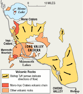
Both Mammoth Mountain and Long Valley Caldera are located in Eastern California, very close to the Nevada border. It takes about 6 hours to get from the San Fernando Valley to Mammoth Mountain.

Mammoth, in particular, lies near the Sierra Nevada mountain range – towering and beautiful peaks that are the leftover pieces from huge, ancient volcanoes which used to exist here.

The closeness of Mammoth Mountain and the Long Valley Caldera to the Sierra Nevada has given scientists possible clues to solve the tectonic mystery of how these volcanoes formed.

Some scientists believe that millions of years ago the plate boundary between the North American plate and the Pacific Ocean used to be much farther east than it currently is.
 
This means that California did not exist! And the coast of the Pacific Ocean instead was located on the California-Nevada border – right near where the Sierra Nevada is currently found.

The border between Nevada and the Pacific Ocean formed a convergent plate boundary, where the two plates are coming together or colliding.

There, a subduction zone formed between the North American plate and the Farallon plate (which doesn’t exist anymore).

This zone formed the Sierra Nevada range, and scientists believe that this could also be the mysterious cause of the Mammoth mountain volcano and the Long Valley Caldera.

Wednesday, December 21, 2011

Volcanoes: Mount Shasta


Volcanoes: Mount Shasta

Mount Shasta provides beautiful views to the small mountain communities that surround it. But the possibility of an eruption has these villages preparing for the worst.
 
Mount Shasta is the second highest volcano in the United States, and one of the tallest peaks in the Cascade Range. Though there is just one mountain, it is actually made up of a handful of volcanic vents (where lava could someday erupt from).
 
It is a relatively young volcano. But it was actually formed on earlier volcanic mountains that have been erupting in this area for the last 600,000 years.
 
According to geologists, there is a one in four or one in three chance that Mount Shasta could erupt in our lifetimes.
 
Even now, the mountain experiences constant volcanic activity – though it is not strong enough for most people to notice.
 
The most recent eruption occurred about 200 years ago – and it was so large that it caused a huge tsunami in Japan, several thousand miles away.
 
Despite the chance that the volcano could erupt, Mount Shasta remains a popular tourist destination.